|
|
 |
|
|
|
|
Loess (pronounced "luss") is a German word meaning
"loose" and it is the name of a type of soil. Loess is a deposit of fine, yellowish-gray, clay-like sediment which can be
found from north central Europe to eastern China and in the American Midwest. Loess deposits are especially common at the
edges of large river basins and are generally thought to be made up of material carried by winds that went through the area
during and after glacial periods.
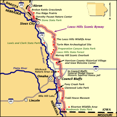
The Loess Hills . . . stretch from the town of Westfield in central Plymouth County,
Iowa, to just south of the Squaw Creek National Wildlife Refuge in central Holt County, Missouri. Between those two points,
the Loess Hills form a north-south band of varying width approximately 200 miles long. Deep loess landforms are best developed
in a strip between 3 and 10 miles wide along the edge of the Missouri River valley. In general, the bank of deep loess landforms
is greatest to the north, in Harrison, Monona, Woodbury, and Plymouth counties, Iowa. It narrows to the south, in places becoming
extremely thin. For much of their extent in Missouri, the Loess Hills are reduced to a sliver that barely extends east of
the westernmost bluffs.
--from Fragile Giants A Natural History of the Loess Hills
by
Cornelia F. Mutel, University of Iowa Press, Iowa City. 1989
|
|
|
|
|
|
Known as the Loess Hills, they were formed between 30,000
and 12,000 years ago, a time of periodic ice ages interspersed with warmer intervals. Whenever glaciers melted, rivers rushed
through what is now the Missouri River valley, carrying silty sediments. During colder periods, these sediments dried out,
and the fine particles of quartz that lay on the surface were picked up by strong westerly winds, blown eastward, and redeposited
along the low walls of the river valley.
--from Field Guide and Natural History,
by Robert H. Mohlenbrock,
November 1996, Volume 105, Number 11..
|
|
|
|
|
|
|
|
|